PANGEOTEK

PANGEOTEK StrataScope
Expert-Led Drilling Duration Realism for Large-Diameter Drilling Powered by StrataScope
StrataScope is Pangeotek’s proprietary internal drilling performance modelling framework used to deliver expert‑led drilling duration realism reviews for large‑diameter drilling projects.
Rather than relying on optimistic penetration rates or averaged productivity assumptions, StrataScope explicitly models stratigraphy, controlling geological intervals and operational constraints.
The result is a planning‑grade drilling duration assessment that is transparent, auditable and defensible for FEED studies, design development and delivery planning
We use StrataScope to deliver:
Stratigraphy-Driven Performance
We translate ground models directly into drilling behaviour rather than relying on averaged productivity assumptions. Geological layers, transitions and controlling intervals are explicitly represented so that drilling duration reflects the actual stratigraphic conditions encountered during installation
Scenario-Driven Duration Analysis
Alternative execution assumptions can be tested within the same geological framework. Scenario modelling allows planners to understand how changes in drilling approach, operational allowances or programme assumptions influence the resulting drilling duration ranges.
Explicit Operational Modelling
Operational drivers such as drilling method, tooling configuration, penetration behaviour and operational constraints are modelled independently from geology. This separation makes it clear which elements of programme duration are governed by ground conditions and which arise from execution decisions.
Transparent Calculation Architecture
Every step in the modelling process is traceable to the underlying inputs and assumptions. The calculation structure is transparent, allowing engineers, planners and reviewers to understand how duration ranges are constructed rather than relying on opaque spreadsheet outputs.
Controlling Interval Identification
StrataScope highlights the geological intervals most likely to control drilling duration. By identifying slow-ground dominance and stratigraphic transitions early, the model exposes where programme risk is concentrated rather than distributing duration evenly across the profile.
Assumption
Traceability
All geological interpretations, operational allowances and modelling assumptions are documented within a structured register. This ensures the duration assessment can be audited, reviewed and challenged, supporting confident decision-making at FEED, design and governance stages.
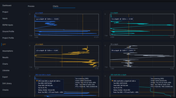
Drilling Forecasts Made Visible
 |  |  |  |
|---|---|---|---|
 |

What Clients
Receive
Planning-grade Drilling
Duration Realism Assessment
Identification of Controlling Geological Intervals
Separation of Geological and Operational Drivers
P10 / P50 / P90
Programme Ranges
Structured scenario commentary
Technical Memorandum Suitable
for Governance Review
Why This
Matters
Reduce Optimism in Drilling Duration Forecasts
Identify Geology-driven Programme Risk Early
Compare Drilling Scenarios on a Consistent Basis
Support Internal Governance and Project Decision Making
Reduce Late-stage Schedule Surprises
Where It
Adds Value
Offshore Wind Foundations
Ports and Marine Infrastructure
Large-diameter Drilled Piles and Sockets
Projects Where Subsurface Uncertainty can Materially Affect Installation Duration
Projects Requiring Defensible FEED
Stage Programme Realism
Contact us to see how we can improve
your site assessments